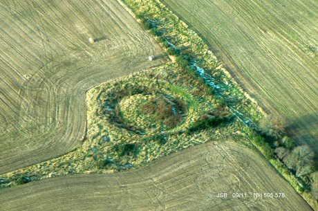
Culbokie Henge
Culbokie Henge is situated at the top of a field overlooking the inner Cromarty Firth. The earthworks are well preserved and the ditch and bank can be traced easily.
Speaking with the old farmer, many years ago, who owned the land, there used to be a stone avenue that led off from the henge down the hillside towards the water. From what I recall the avenue wasn't complete but included a "fair number" of stones. The orientation would have been towards the west looking at Ben Wyvis. He remembered helping his father pull them out and they were discarded in the area; it should be noted the small greenlane that follows the fields near to the henge had many big stones along the boundary.
Description from RCAHMS
Culbokie, Henge Monument: A ditch 26' wide encloses a roughly circular area averaging 48' in diameter The present width of an entrance to the E is 33'. The diameter from crest to crest of the banks varies from 90' to 96'.
Feachem (R W Feachem 1963) states that, at frist sight, this is a Class I henge, but as the bank runs across the entrance causeway only excavation can determine whether the bank was originally fully annular. If so, this can at best be called a proto-henge or hengiform earthwork. Whether henge or not, it is extremely likely to be of about 2nd or 3rd millenium B C date.
A A Woodham 1955, R W Feachem 1963.
Travel Directions to Culbokie Henge
Just off the B9169. Find a place to stop the car and then explore