Meaning: Peak of Goats
Munro Region: Strath Orchy to Loch Leven
Munro Number: 54
Height in Metres: 1090
Height in Feet: 3578
OS Map Reference OS Sheet 50; 230455
Description:
These two mountains rise a few kilometres north-west of the west end of Loch Tulla. Stob Ghabhar is a particularly fine peak with its summit standing on the edge of the cliffs at the head of its great east-facing corrie. This side of the mountain is well seen from the road across Rannoch Moor. Stob a' Choire Odhair is a much lower peak, but it also looks impressive as seen from the east.
The ascent of these two mountains is usually made from the west end of Loch Tulla. Go along the track to Clashgour for 1½ kilometres and turn right along the path on the east side of the Allt Toaig. Go up it for 2½ kilometres and then climb a zigzag stalker's path up the steep slopes of Stob a' Choire Odhair. This path leads high up onto the hill and ends a short distance from the summit.
To continue the traverse, go west down a broad stony ridge to the col at the head of Coire Toaig. Climb steeply to reach the east ridge of Stob Ghabhar, and traverse its narrow rocky crest to reach the summit. The descent goes south-east down wide grassy slopes to the Allt Toaig where a safe crossing place should be found to regain the path on the east side.
Print
Email
Meaning: Peak of the Large Rounded Hill
Munro Region: Loch Linnhe to Loch Ericht
Munro Number: 49
Height in Metres: 1099
Height in Feet: 3606
OS Map Reference OS Sheet 41; 165667
Description:
Sgurr a' Mhaim is the highest mountain in the western half of the Mamores and it stands in a fine position above Glen Nevis , a prominent feature of the view up the glen from Fort William. Like Stob Ban, its upper slopes are covered with quartzite boulders which give the mountain a pale grey appearance. The finest feature of the mountain is its south ridge leading to the two Tops, Stob Choire a' Mhail and Sgor an Iubhair. This ridge, known as the Devil's Ridge, is very narrow and in winter has a decidedly Alpine appearance.
The ascent is most easily made from Achriabhach in Glen Nevis. Follow the stalker's path towards Coire a' Mhusgain for a short distance and then strike directly up the north-west shoulder of Sgurr a' Mhaim]] which gives a long steady climb to the summit, at first up grassy slopes and then on quartzite boulders and scree. There is a path for most of the way.
Instead of descending by the same route, go south along the narrow ridge to Stob Choire a' Mhail. Care is needed, particularly in winter, at the narrow part of the ridge, which is quite exposed. At the col before Sgor an Iubhair a stalker's path leads down in steep zigzags to the col at the head of Coire a' Mhusgain. Return to Glen Nevis by the path down this corrie.
Print
Email
This section includes some of the highest and finest mountains in Scotland, most notably Ben Nevis, the highest of them all. In the south-west corner of the area, between Loch Leven and Glen Nevis, is the long ridge of the Mamores.
The ten Munros in this range include Binnein Mor and Sgurr a' Mhaim, both fine mountains with narrow crests, and all the peaks except two are linked by high ridges which makes the traverse of the Mamores a splendid expedition.
Opposite them, on the north side of Glen Nevis, Ben Nevis dominates not only the town of Fort William at its foot, but also its nearby high mountains - Carn Mor Dearg, Aonach Beag and Aonach Mor. Although these three are high by the standards of other Scottish mountains, they are very much in the shadow of their greater neighbour. To the east of the Aonachs another long ridge, the Grey Corries, includes three fine mountains - Sgurr Choinnich Mor, Stob Coire an Laoigh and Stob Choire Claurigh.
Continuing eastwards beyond the Lairig Leacach, Loch Treig is deeply enclosed between the steep flanks of Stob a' Choire Mheadhoin and Stob Coire Easain on its west and Stob Coire Sgriodain on its east. Other hills of lesser height and character in the area near Loch Ossian include Chno Dearg, Beinn na Lap, Carn Dearg and Sgor Gaibhre.
To the north-east of Loch Ossian, extending in a long continuous ridge towards Loch Pattack, there are four high mountains - Beinn Eibhinn, Aonach Beag, Geal-Charn and Carn Dearg - and to their north Beinn a' Chlachair is the highest of three hills above Loch Laggan.
Finally, at the eastern edge of this section, there is Ben Alder and its much smaller neighbour Beinn Bheoil on the west side of Loch Ericht. Ben Alder is a high and remote massif with an extensive summit plateau surrounded by steep corries, and it may well be described as the finest mountain between Ben Nevis and the Cairngorms.
Print
Email
Lorraine Wakefield steps out on The Great Glen Way, a new long distance route from Fort William to Inverness that aims to have walkers crossing from west to east.
Scotland's highest mountain, longest glen, most famous loch and most mysterious resident are all features on the country's newest long distance route the Great Glen Way which opens on 30 April.
The Great Glen Way stretches from Fort William in the west to Inverness in the east and on the way passes Ben Nevis, covers the length of the glen, goes along the shores of Loch Ness and of course gives walkers the chance to spot the elusive Nessie.
The 73 mile waymarked route takes in some of Scotland's most spectacular scenery and natural heritage using paths, old railway lines, canal towpaths and sections of General Wade's Military Road as it winds its way along the Great Glen, which runs along a geological fault line.
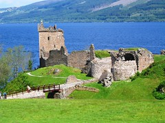
Along the way its passes important historic attractions like Urquhart Castle, the village of Fort Augustus and the magnificent engineering of the Caledonian Canal that links the two coasts of Scotland via a series of lochs situated in the glen.
It is hoped that the Great Glen Way can build on the success of other long distance routes like the West Highland Way and the Speyside Way to help bring more visitors to Scotland and raise awareness of the spectacular environment and natural heritage found in Scotland.
The Great Glen Way route manager Alastair MacLeod said they have had enquiries from as far afield as Japan, North and South America, Europe and all over Britain from people wishing to walk the route and already there is a huge interest from visitors.
"We have had a lot of enquiries in the last few months and the majority of them are people who are going to do the whole Great Glen Way," explained Alastair.
"We anticipated the majority of walkers would be coming from Fort William and heading to Inverness but I have been pleasantly surprised by the amount of people wanting to do it from Inverness to Fort William," he added.
The good thing about the Great Glen Way however is that it is not designed only for serious walkers completing the whole route but is accessible to those wishing to have a day's outing as they can easily choose to walk just one section of the route.
"That is one of the great attractions of the route," continued Alastair. "Let's say you were based in Fort William and wanted to do a piece of the route, you would be able to use public services to get to Spean Bridge and then could walk back along the footpaths and towpaths to Fort William.
"At Inverness it is the same as you can make your way along the Great Glen Way out to Blackfold and then come back down to the (Caledonian) canal or do it the other way and take the bus out to Drumnadrochit and walk back to Inverness.
"There are a lot of opportunities for people doing the route in sections and once we are up and running we expect somewhere in the region of 10,000 people will use the facility each year as well as the expected 20 - 25,000 walkers doing the whole route."
The Great Glen Way will undoubtedly help bring more visitors to the area with one hotelier already receiving 400 confirmed bookings directly linked to the new route and Alastair said the route would give a big boost to the area.
"The thinking behind the provision of the long distance route is that there should be economic spin offs for all the communities along the way and there are opportunities, particularly in tourism, to capitalise on that," he said.
"Since we announced the creation of the route a significant number of people in communities along the way has provided extra accommodation with the creation of bunkhouses and chalet parks and maybe people who did not do bed and breakfast before are now going into it because they are adjacent to the route.
"I was speaking to a hotelier that said he had 400 confirmed bookings for people directly linked to the Great Glen Way that he did not have last year and that is really significant."
The Great Glen Way is about more than just a waymarked route however as the route is supported by four rangers who will work in two strong teams to help maintain the way, meet walkers and care for the natural heritage.
"We see our prime role first of all to service the public and that is those users on the route," said Alastair. "Our rangers will be on the route on a regular basis where people using the way will have the opportunity to stop and speak to them and they will be able to advise people on what they are seeing or what they can see around them.
"That's the main role but having said that we also see it as a great opportunity for us to directly liaise with community councils and local schools along the way and develop the environmental theme. We also see connection with the business community, local enterprises and so on.
"It is really by two way communication that we will be able to provide a better service and the service that the local communities and the walkers are looking for that will benefit everyone in the longer term."
The Great Glen Way will be officially opened by Prince Andrew in Inverness on 30 April when he will meet Alexander Morton, walking on behalf of the Highland Society for Blind People, who will be the first person to complete the new route and will present a scroll of greetings from Lochaber on his arrival from Fort William.
Also joining Alexander for the last bit of the route will be Grantown Grammar School pupils, the Great Glen Way rangers and route manager Alastair himself. Prince Andrew will unveil a plinth at Inverness Castle, which is one of the official termini of the route, the other being the Old Fort in Fort William.
Visit the Great Glen Way website at http://www.greatglenway.com for more information.
25/4/2002
Print
Email
Glen Shee to Mount Keen
The area included in this section of Munro's Tables includes much of the eastern part of the Mounth, and for the most part it is a vast high plateau from which many of the mountains rise as rounded domes. The finest impression of this area is from Deeside to the north. From many points between Aboyne and Ballater, Lochnagar is seen rising to its full height above the valley, and from further up the River Dee at Invercauld Bridge the plateau of the White Mounth appears far above the pinewoods of Ballochbuie Forest. The south-west corner of the Mounth plateau reaches the Cairnwell Pass, and from the A93 road across this pass the western hills of this area rise in a long line - Creag Leacach, Glas Maol, Cairn of Claise and Carn an Tuirc. All very accessible from the road. To their north-east the plateau stretches far towards Lochnagar; Tolmount, Tom Buidhe, Cairn Bannoch and Carn an t-Sagairt Mor being high points on this undulating expanse of tundra. Broad Cairn is a more prominent mountain with the great cliffs of Creag an Dubh-loch above the head of Loch Muick. Near the north edge of the Mounth, Carn a' Choire Bhoidheach, sometimes referred to as the White Mounth, is another high undulation, but just to its north the plateau ends abruptly at the steep cliffs above Loch nan Eun.
A few kilometres further east stands Lochnagar, the finest peak of the Mounth, and one of the finest in Scotland. Although from the south-west it appears to rise only slightly above the level of the plateau, from the north and east its true height and character are well seen, the mountain forming a great cirque of cliffs above the corrie which holds the loch of the same name.
Mount Keen is an outlier of the Munros, rising far to the east of Lochnagar in an area of lower hills and high moorland, and on the southern edge of the Mounth, Driesh and Mayar stand between Glen Clova and Glen Prosen.
Print
Email
AVOIDING THE MIDDLEGROUND OF MILD ENTHUSIASM
Galloway and its hills are a bit of an unknown quantity for most people but Dave Hewitt enthuses about the region and suggests more walkers should pay a visit.
To Galloway in late February, for Pete Drummond's final Donald. I used to go to Galloway often, particularly in the early and mid-1990s when I was living in Glasgow (handier than the current Stirling) and working through the Donalds myself.
Then there was a spell spent accompanying a Kilmarnock-based friend on the latter stages of his round, with the odd below-Donald-height trip thrown in as well. (Donalds are non-Highland Scottish hills over 610m/2000ft, basically.) Recent years have seen fewer visits however and I'd half forgotten, until rolling in along the A712 for Pete's do, how much I missed the place.
Galloway is an area like no other and I became - and remain - extremely fond of its strange combination of very easy walking - forest tracks everywhere - and the hardest, roughest, most tangled undergrowth to be found in Scotland. Forget Knoydart's Rough Bounds, Sutherland's hag-and-lochan moors or even the mid-height heathery bits of the Mounth or Kintyre: Galloway is in a class of its own, particularly in high summer when, to hijack a Michael Marra phrase, "the undergrowth is overgrown" and the air is stacked with wide-bodied insects circling as they lower their landing gear.
Just a few weeks before his completion jaunt, Pete Drummond had picked off the Galloway-heartland Donalds of Mullwharchar and Dungeon Hill, and he was wise to have done these in a frosty winter spell. In summer these are adventurous hills, requiring more effort and far more sweating and swearing, than a glance at the map or the altimeter might suggest.
For a good number of people reading this, there will be no need to explain the offbeat enjoyability of Galloway. The place has not just converts but also addicts, those for whom it is the best part of Scotland, the place to which they return more than anywhere else, just as some people are unable to stray from the Cairngorms, Skye or Assynt for very long.
But for others, Galloway will be a closed book, an area they have either never been to at all or where just one or two of the more landmarkish hills will have been picked off by uncharacteristically well-worn routes - Merrick, say, or Cairnsmore of Fleet from its southwestern side (the northern approaches are as rough as it gets - it's a very different hill via Craignelder), or maybe the eastern outlier of Criffel.
In a way, people's knowledge of Galloway tends to mimic the all-or-nothing mood of the place itself. There is easy walking and hard walking but next to nothing between. And there are those who go there often and those who never go at all but hardly anyone who occupies the middleground of mild enthusiasm. People tend to either love it or hate it, regard it as the finest of all acquired tastes or the worst of all possible dog's dinners.
Because of this and because of its geographical off-to-one-side nature (readily ignored by English types zooming up the M74 for their Munros and likewise snubbed by Scots heading south for a bit of fellbashing), Galloway is never going to be popular, even less trendy. It's massive, though - I once arranged to meet my sister in a cottage in Kirkcudbright and opted to cycle there from Dumfries. This took about twice as long as anticipated, despite good roads and a relatively quiet day on the headwind front. But even then I was only halfway across what could be termed Greater Galloway and the area stretches at least as far on the north-south axis as it does on the east-west.
It can also feel a long and tortuous way from anywhere by car. On the recent visit I had to head home that same evening and it felt like a major day once I'd driven 110 miles each way to and from the Murray's Monument car park west of Clatteringshaws. (For the record, the way I went - M74, then through the wonderful Dalveen Pass to Thornhill and the longer-than-it-looks Corriedoo road to New Galloway - was pretty much identical in time/distance to the return route through Dalmellington and the south side of Glasgow.)
Pete's chosen last in the list was Millfore, a sort of semi-outlier. Nothing like as cut off as traditional last Donalds such as Tinto, Cauldcleuch Head or the Cairnsmore of Fleet massif but still adrift enough from its Minnigaff neighbours Larg Hill, Lamachan Hill and Curleywee (great hill, great name - it's like a bigger version of Dumgoyne) for it to be most often tackled as a lone-hill outing. I'd been on it three times before - initially alone from Craigencallie to the northeast in April 1990, then as part of the full Minnigaff round from Auchinleck to the south in March 1991 and finally with my sister and her man - probably on that cycling holiday - again from Craigencallie. That had been in September 1993, so almost a decade had passed - scary.
This time we went from the monument, zigzagged around the Black Loch, then met the Craigencallie route at a sketchy path leading northwestward from the Poultrybuie Hill shoulder. It was a stroll in hazily benign conditions until meeting a strong and bitter east wind on the very highest slopes. Suddenly it was hard to stand up straight and we - there were five of us - were glad to tuck ourselves into the summit slope for lunch and completion cake.
(Anyone studying the 1997 edition of Munro's Tables, incidentally, risks being puzzled by Millfore's height. It's a Graham as well as a Donald, and the list of Grahams labels it a 657m hill whereas Percy Donald's list gives 656m. The grid ref is the same in each case but the Grahams figure is correct ' the 656m height is that of the trig point but there is a cairn around a metre higher just a few strides to the southwest.)
So Pete was complete, having started his Donalds with smooth Broad Law - almost the antithesis of Galloway - on 17 October 1964. A longer than average round - it's not uncommon to tick off the whole list of 140 summits (or a mere 118 if using Alan Dawson's New Donalds alternative) in half a dozen years. My erstwhile stand-in, Ronald Turnbull, holds the record for the fastest self-propelled round, and an extraordinary record at that - all 140 summits, plus ten "discards and extras", in nine days, 14 hours and 25 minutes. This was in May 1995, when he was young and keen and fit.
The oddest thing about Millfore is that for all its unsungness, it's now the joint fourth most common finishing Donald, having hosted three of the 93 known completions. For full details of who did what and when, have a look at the list here.
The day was young (and keen and fit), so there was support for my plan to head east for Craignell, a 477m Marilyn en route (ish) back to the road. This proved to be the best part of the day, conditions-wise, the skies retained their summer-like haze and the descent of the east side of Millfore was much rougher than the easy southern approach - typical Galloway, this. Nothing desperate but the small crags of Buckdas of Cairnbaber (where do they get these names?) needed picking through and there was some ice and a little residual snow. From below, in the haze, the summit we had left could easily have been taken for a Munro.
A high quality, semi-metalled forest road crosses the col before the intervening summit of Munwhul and half the party opted out here, preferring an amble back rather than the rough stuff beyond. We righteous ones continued, dipping again to power lines (where an unmapped track comes in from the north) and a steep-as-heather-comes haul up the ridge of Bennan, twig-clutching stuff but enjoyable in its way.
After regrouping and recovering on one of the summit slabs, all that remained was the treat of a traverse round to Craignell itself, not often climbed but a little hill with a disproportionate sense of space and remoteness. The descent southeast then south was trivial apart from a bit of Grade 1 tree scrabbling and soon we were back on track. The day's final pleasure was a rather eerie carved face on a stone in a gateway just before the final drop to the road. We hadn't noticed this on the way up as it had had its back - a plain uncarved stone - turned to us.
So a satisfying and very satisfactory day - more than six hours round, although we festered a fair bit up top. The views weren't great but the company was good and the landscape terrific. Needless to say, we didn't see or meet another soul. I could, I think, live in these parts and do the vast bulk of my walking on the Gallowegian hills. The megadamp climate would do my head in but better wet and hilly than dry and flat.
A couple of parish notices to end with. Ian Chalmers found an exposed film between Meall a'Bhuachaille and Creagan Gorm on Saturday 22 February - the same day that Pete Drummond was on Millfore, in fact. The film was lying near the top of the path leading down to Loch Morlich, at NH985116 on Landranger 36 and Ian reports that it appeared to have been dropped that day and was "not a bog standard Kodak but clearly used by someone keen on high-standard photography". If you think the film was yours, email Ian at This email address is being protected from spambots. You need JavaScript enabled to view it.
Short notice, I know, but Friday 21 March sees the annual Grampian Club lecture, to be given this year by the excellent and interesting Bob Aitken. He'll be speaking on "W H Murray - The Landscape Legacy", starting at 7.30pm in the Tower Extension lecture theatre at Dundee University. Tickets at the door - £4.
And that, I'm afraid to say, is the last of my Scotland On Line pieces. Chris Tyler (the cartoonist) and I would like to thank readers for their support, interest, thoughts and feedback over the two-and-a-half years that we've been doing this. Hopefully it's been informative, entertaining and stimulating, with not too much dull or mediocre stuff.
You'll still be able to find Chris and me in our other incarnation at The Angry Corrie - issue TAC57 goes to press this week and online versions of the previous 56 issues can be found here.
In respect of the Scotland On Line columns, thanks are due to Lorraine Wakefield and the late Alan Matheson for making the site such a lively and hillgoer-friendly place and also to everyone out there for being such an exceptionally good and friendly bunch of readers. It's been a pleasure.
Dave Hewitt
20/3/2003
from Scotland Online / Travel Scotland archives
More details about Walking In Scotland
Print
Email
Meaning: Possibly from creis, meaning a Narrow Defile
Munro Region: Strath Orchy to Loch Leven
Munro Number: 48
Height in Metres: 1100
Height in Feet: 3609
OS Map Reference OS Sheets 41 and 50; 238507
Description:
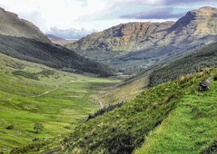
These two mountains are the highest points at the north end of the great range of the Black Mount. They look very impressive as seen from Kingshouse Hotel, particularly Creise and its projecting ridge Sron na Creise which form a steep face above the Cam Ghleann. Creise is the highest point of a long level ridge from Clach Leathad to Sron na Creise, and from the middle of this ridge a spur juts out towards Rannoch Moor, with Meall a' Bhuiridh at its end.
The simplest ascent of these two mountains starts from the carpark at the foot of Meall a' Bhuiridh and goes up the north-west side of Coire Pollach, avoiding the ski tows and chair lifts. This leads directly to the summit of Meall a' Bhuiridh. Descend the narrow west ridge and from the col at its foot climb steeply to the ridge above. In winter and spring this climb will probably be up steep snow with a cornice at the top. Turn north along the broad level ridge for 600 metres to reach Creise. Return by the same way.
An alternative route to Creise is round the foot of Creag Dhubh to the Cam Ghleann and then by a steep climb to either Sron na Creise or Stob a' Ghlais Choire , but these routes involve some steep scrambling and are only for the experienced.
Print
Email
CORBETT'S COMPLETION
John Rooke Corbett is thought to have completed the amazing feat of climbing all of Scotland's 2000ft hills. Dave Hewitt thinks this may be a mistake in history but nonetheless Corbett is one of his favourite characters.
Maybe it's the sceptic in me, but I'm interested in those statements and traditions, which if subjected to even a few seconds of scrutiny, prompt a realisation that they're almost certainly utter nonsense. Take, by way of example, the oft-heard belief that the age of a cat is one-seventh that of a human. Loads of people take this as an absolute, handed-down truth, such that if encountering a cat aged, say, eight, they'll do the mental arithmetic and volunteer that it's actually 56 in "our" terms.
Well, they might be able to do sums but they can't do logic. It doesn't take much to discover that domestic cats routinely live to age 15, quite often up towards 20. (A blind Siamese round the corner from us died earlier this year aged 21 - and, while its owners were aware that this was a good innings, they weren't phoning the Guinness world records people.) If 15 is taken as the benchmark, then 7x15 = 105: an age which hardly any humans reach. The real "conversion" figure, if such a biologically tenuous idea is to be invoked, is surely five, with six as an absolute upper limit. Seeing a 15-year-old cat as the equivalent of a 75-year-old human is reasonable; seeing it as a centenarian and then some is laughable. But still people trot this out, often educated, seemingly numerate people, and I suspect that when I eventually die aged 147 the tradition will be just as strong as ever.
I mention this because of the following statement, included on page 6 of the new SMC Corbetts guidebook (The Corbetts and other Scottish hills), "[Corbett] completed the Munros and Tops in 1930, only the second person to do so and, more remarkably, he climbed all Scotland's 2000ft hills." Now the first part of this is fine - John Rooke Corbett did indeed complete the Munros and Tops in 1930 - in June of that year to be more precise (although, as with so much concerning Corbett's life and hill career, the exact date hasn't yet been pinned down). The finish came on Buachaille Etive Mor and his eventual obituarist S F "Mac" Forrester (writing in the 1950 Rucksack Club Journal) noted that Corbett claimed he was unable to celebrate properly due to having left "a sister and two maiden aunts in the car".
So that bit is correct. The problem comes with the assertion that "he climbed all Scotland's 2000ft hills." This might be true - with a hefty italicised emphasis on might - but I strongly suspect it's not. As with the cat example, think for a moment what is actually being said here. Perhaps the easiest way to do this is to compare the statement with its most commonly heard equivalent - that so-and-so climbed all of England's 2000ft hills. This latter feat is an eminently manageable target - not trivial, but hardly a life's work. In terms of what it means, definition-wise, it usually involves all English summits above 2000ft/610m in height with a specified drop, commonly 100ft or 30m.
The first person to achieve this appears to have been W T Elmslie, who completed a list of 348 summits on 25 November 1944. Next came Ernest Moss (who had published his own version of the English list in the Rucksack Club Journal of 1939). Moss completed on 22 July 1951, and was followed by Clem Clements on 30 May 1953 - the day after the successful completion of a rather better publicised hill enterprise a few thousand miles to the southeast. Then came A St G Walsh, another who worked from his own list (see the Wayfarer's Journal, 1950) and who finished on the not-really-English Snaefell on the last day of 1953. There might have been others in the gaps between these four, there might have been someone ahead of Elmslie; but the point is that this list, in its various forms, was completed pretty early in proceedings. It was do-able, and it was done.
Applying this same 100ft/30m drop criterion to the Scottish 2000ers opens a few floodgates, however, as a claim to have climbed all the hills requires: (a) Munros and Tops - well, let's be generous and count only those Munro Tops with 30m drop, ie 455 summits; (b) the Corbetts and their associated tops: 669 of these; and (c) the Grahams and their tops. Alan Dawson, Clem Clements (happily still with us and due to enter his ninth decade next March) and I are working on the list of Graham Tops, and hope to publish sometime mid-2003. We don't as yet have an exact figure, but it looks like around 1000 hills are involved. So, using the English model, anyone climbing the Scottish 2000ers needs to visit in the region of 2100 summits.
As things stand, only one person is known to have climbed all the Corbett Tops: James Gordon, who completed on Marg na Craige above Laggan on 24 February this year. He has also been round Munros, Munro Tops and Grahams, so has done a lot of legwork, but is still lacking around one third of the full Scottish 2000er set, due to his not (yet) having tackled the subsidiary Graham Tops. The great Colin Dodgson (died 27 July 1991) visited a similar number of hills during a lifetime spent working through Willie Docharty's books of tables (published 1954 and 1962); but, despite being the most prolific British hillbagger of the immediate postwar period, it doesn't appear that Dodgson got close to the all-the-2000ers finishing-line, either.
It thus seems scarcely credible that Corbett could have climbed all the hills in question, so let's make the requirement easier. Let's just say that climbing "all Scotland's 2000ft hills" can be claimed if a much less rigorous drop criterion is invoked. The obvious choice is the traditional 500ft/150m requirement, under which "all Scotland's 2000ft hills" would be applicable to anyone who has been round Munros, Corbetts and Grahams.
Corbetts are defined by 500ft of all-round drop, Grahams by the slightly less strict 150m, but only 205 of the current 284 Munros have separation on this scale. So the least-strict definition of "all Scotland's 2000ft hills" could be said to equate to 205 Munros plus 219 Corbetts plus 224 Grahams, ie 648 summits. Let's call it a round 650 to accommodate the various map/height changes since Corbett's time.
This is a far less arduous task than the 2100-odd summits of the 30m-drop rule, and has been shown to be manageable. At the time of writing only 20 people are known to have completed the Grahams (see list here - the most recent finish came from Mike Dixon of the Inverness Mountaineering Club on Beinn a'Chearcaill, 17 November). Of these 20 Grahamists, all bar two have also completed Munros and Corbetts, ie have been up all the 650-odd hills in question. So this, like the English 2000ers, can be done - and the first person to achieve it appears to have been Dodgson, who wrapped up the Docharties (the forerunners of the Grahams) with Beinn a'Mhuinidh on 4 July 1984.
The question is, could John Rooke Corbett, who died on 13 August 1949 having been relatively inactive in his final years due to ill-health, have completed this threefold set of hills some 40 years before Dodgson? If so, then the statement about his 2000ers can be seen as correct (or at least valid: speaking with various modern-day compleaters, it's clear that climbing these 650 hills doesn't lead them to think they've completed the set of Scottish 2000ers).
Corbett was the Dodgson of his time, a man about whom the phrase "the greatest walker of his generation" was used with justification. Indeed, there is scope for a succession to be drawn up for this title, with only a few genuine candidates in any given period - Corbett / A W Wakefield / Eustace Thomas prewar, then Dodgson / Willie Docharty / Philip Tranter / Anne Littlejohn through until the 1970s, then Ann and Rowland Bowker, Hamish Brown, Charles Knowles and Phil Cooper through the 1970s and 80s, and the likes of Rob Woodall and Ken Whyte in the modern era. Each of these periods will have seen other candidates, including unpublicised walkers whose names we'll never know, but if the "greatest walker" title goes to an eclectic hillgoer with an appetite for completing any list that comes their way, then these names are among those which must come into consideration.
So Corbett was a great walker, but that doesn't answer the question. The way to tackle this is to find out where the "all Scottish 2000ft hills" phrase came from - which brings us to the 1950 SMC Journal's obituary of Corbett, written by Robin Gall Inglis. It was an affectionate tribute - "The well-known, kindly face of J Rooke Corbett will no more be seen in our midst; a giant among hill lovers has made his last ascent..." - and included two phrases of specific relevance here. The first is this: "It is not likely that his record of Scottish ascents will ever be broken." The second - which surely gave rise to the 2000er phrase in its present form - is this: "Not long before the heart attack, in 1943, that ended his climbing but happily not his walking days, he accomplished a long-cherished ambition of completing the ascent of every 2000-foot eminence in Scotland."
This appears to be even clearer than the current version and - if true - leans more towards the 2100-summit option than to the easier Munros plus Corbetts plus Docharties/Grahams alternative. The phrase has been quoted a time or two (eg see page 80 of Robin N Campbell's The Munroist's Companion), and appears to take its current form via Hamish Brown, who in the introduction to his Climbing the Corbetts wrote: "[Corbett] also made the ascent of every 2000-foot hill in Scotland, still a very rare feat."
Crucially, we're not hearing the voice of Corbett himself. Some of his hill-related papers were handed to the SMC after his death, and it was the editing of these which led to the modern list of Scottish 2500ft hills. These papers have disappeared however, and although I've been asking around SMC sources, nothing has come up as yet. If and when the papers do resurface, things should become much clearer. What must be said is that there's no suggestion of Corbett having made any kind of dishonest claim - he was noted for his thoughtfulness and integrity, and came from Quaker stock (and after several years of researching his life and hill career, he's become my favourite hill character from that era, the one I would most have liked to have met).
So only two possible conclusions are likely. It could be that the claim will be borne out by evidence - that Corbett did indeed visit hundreds of unsung 2000ft hills across Scotland. Far more likely however is that a mistake was made in transcription (and/or in comprehension) circa 1950, and that "all Scottish 2000ft hills" should actually read "all Scottish 2500ft hills".
This would make much more sense. Hills in the 2500ft-2999ft bracket were Corbett's speciality, and he had been detailing them for years, initially in the Rucksack Club Journal, where he called them "25s". He climbed the English and Welsh 25s early in proceedings (being a Manchester man who moved to Bristol, he was handily placed). Then, having completed his Munros in 1930, he began to devote serious time and energy to the Scottish 25s. There are periodic references to this in SMC journals of the period, with Corbett turning up at club meets, marching off for sub-Munro hills and being gently ridiculed for his eccentricity. But Corbett was ageing - he was already in his early 50s when he completed the Munros - and while there was time for him to climb all the Corbetts, there surely wasn't scope for adding the Docharty/Grahams, never mind the hundreds of outlying tops.
Corbett's Corbett completion is itself a hazy thing - differing accounts can be taken to mean that he either did or didn't quite complete what is occasionally referred to as his "task". But on the balance of evidence he did complete this list, sometime between 1939 and 1943. Again, an eventual discovery of his papers would confirm this, and would (hopefully) provide a date and a final hill.
One final thought. For all that Corbett no doubt possessed some kind of rudimentary, partial list of hills in the 2000ft-2499ft range - an inevitable by-product of his research on the lower "25s" - there was no published list to work from until the later volumes of Willie Docharty's great (and sadly neglected) series of tables. When it finally appeared, Docharty's 1962 supplement to his Selection of British and Irish Mountain Tops provided a remarkably accurate and ahead-of-its-time list of what we now call Grahams. Docharty knew his stuff, in other words. And Docharty's hill diaries are available for scrutiny - 30 or so leather-bound, meticulously detailed, hard to decipher volumes stored in the National Library of Scotland.
In the back of one of these diaries is Robin Gall Inglis' original SMC letter notifying club members of the death of Corbett. It's the original version of the eventual obituary, and includes the key phrase about Corbett having "accomplished a long-cherished ambition of completing the ascent of every 2000-foot eminence in Scotland." And here, on the letter, in Willie Docharty's sloping hand, is written simply "??".
Docharty had known immediately that this was an extremely odd and dubious claim to make for a man he doubtless knew and respected, and his scepticism serves only to fuel my own, some 50 years on.
Dave Hewitt
12/12/2002
from Scotland Online and Travel Scotland archives
Print
Email